The Puddle Jump
Update# 11
This update was written March 23 during our passage. It gives you a little taste of life at sea. We are currently at the island of Ua Pou in the Marquesas. We'll have lots of details on the islands coming up soon, but wanted to catch you up on details about our passage here.
This is the first of two updates written while on the passage:
Greetings from latitude 13 degrees North and longitude 110 degrees West. It is currently Wednesday, March 23, 2005. As I write this it is 10:30 PM Zihuatanejo, Mexico time. We are planning to switch over to using Zulu time because it will become too confusing to figure out changes in time zones. We have a hard enough time figuring out what day of the week it is!!! Thus, by Zulu time it is Thursday, March 24, 2005 at 0430.
We ended up leaving Zihuatanejo around 7 PM on Thursday, March 17th. (Sticking to Zulu time is going to take some practice!) It's hard to believe that this is our seventh night at sea! We are currently 628 nautical miles into our 2700 mile passage. Thus far we are averaging 100 mile days which are not bad for our small and heavy boat. We are currently at the same latitude as Nicaragua. Longitudinally we are still East of San Diego. We understood the trade winds to be anywhere from 500 to 1000 miles from us at the time we left Zihuatanejo. At over 600 miles we still are not into the trade winds yet.
The wind has been very inconsistent ranging anywhere from no wind to 20 knots of wind. While wind variation is not unusual, what is unusual is that we have seen wind speed build from 5 knots to 15 knots in a matter of 30 seconds! After a minute or few minutes at a higher speed it will all of the sudden die down to 6 or less knots. This makes it difficult in selecting sails, shapes and point of sail. With these conditions you have to be constantly watching and making adjustments. I told Sam today I feel like I'm on Caper racing! For those of you who don’t know, Caper is a J-120 sailboat that Sam has been racing on for a few years.
Sam and I have adjusted to life out at sea. The first overnight is always a bit challenging but then you get into the groove and it's fine. Excited to finally be headed to the South Pacific, I was energized and I actually pulled an all-nighter the first night so Sam could get some much needed sleep. Our watch system that we began when we first started cruising has worked great for us. Many people do two or three hour shifts. Sam and I both cannot function on little sleep and know that we need consecutive hours of sleep to really feel rested. Hence, I take the first watch which begins after sunset and continues on for roughly six or seven hours. Sam then relieves me and I sleep in as late as I want.
I'm sure people are wondering what you can do on a boat for so long. It's amazing but the days are flying by! A typical day includes sailing the boat, keeping a good watch system, putting together meals, cleaning up, working on never ending boat projects, watching in awe at the sea life around us, reading, journaling, talking, praying, playing games, baking, thinking, etc. During my watch I spend some time outside gazing at the sky, watching the phosphorescence activated by the dolphins swimming alongside our boat, checking for traffic and monitoring our location. I also spend time inside journaling, reading, studying French, and listening to the Puddle Jump Net. The net can be heard via SSB and this is where cruisers we know are checking in with their locations, conditions, and whatever else they feel like talking about! We are able to hear the reports through our short wave radio but are unable to transmit. Everyday one of our friends says “Hello” to us on the net rooting us on.
Okay, now to share with you things we have seen since beginning our passage across the Pacific. We have seen dolphins daily though it is more common to see them at night. We've seen sea turtles twice swimming at the surface. We see flying fish multiple times daily and always find some on deck in the morning. We had a set of three fish swimming along with our boat. They remained with the boat in the same position for two days. Sam first discovered them when he was leaning over the side to check out the keel. This morning I woke up to Sam yelling down into the cabin, “Sally, a whale!” I ran up top to see a large whale with a dorsal fin blow and then dive. I saw him blow four more times as he headed off into the horizon. Our least favorite creature we've interacted with on a daily basis is the Boobie. Sam and I have decided it is the stupidest bird in existence. Boobies are known for camping out on sailboats while in transit to the South Pacific. The main problems with them are that they land in places that damage equipment and they don’t have the decency to hang over the side of the boat to relieve themselves. How rude!!! we've heard stories on the net about personal experiences with Boobies. A couple boats boasted about their new pets the first few days only to turn their boasting into cursing. On one boat they’ve had six fatalities from boobies flying straight into their wind generator! I wonder how their nine year old is taking it!!! Thankfully we haven’t witnessed any suicide missions though at times we've felt like we wanted to kill one! Don’t worry my counselor friends, this situation does NOT fit into the criteria for antisocial personality disorder!!!
In addition to all of the life around us, we have been in awe of the daytime sky, clouds and crystal clear, deep blue waters surrounding us. The sun rises and sunsets are amazing! The star filled skies are awesome. Every night when I begin my watch I see the Big Dipper rising on our starboard (right) side and the Southern Cross rising on our port (left) side. This has been thrilling for us because Sam and I love the song “Southern Cross” and have always dreamed of seeing it for the first time by boat together. Out at sea we've become much more familiar with changes in the moon and stars. There are times when a rising star is so bright you're not sure whether it is truly a star or another vessel.
Well, I was hoping to keep this brief but obviously there is so much to tell! There are so many experiences which are new to us. We are thoroughly enjoying this passage in and of itself. We still at times think we're dreaming, that we couldn't really be doing this passage to the South Pacific. I don’t think it has entirely sunk in yet and probably won’t until we arrive.
You are all in our thoughts and prayers and we look forward to hearing from you.
Sincerely,
Sam and Sally
s/v Moana
Written on March 23
en route to the Marquesas
Bonus Update - web-only
On Sunday, April 3, 2005 Sam and I prepared to cross the equator for the first time. When I awoke that morning Sam informed me that Mr. Irwin Mooseltoe (our token Christmas decoration, a Santa Moose) was claiming to be King Neptune and he wanted our champagne. Sam had him sitting on the top of our food hammock holding his torch made from foil. Sam was threatening to throw Mr. Mooseltoe overboard but I explained that he was just experiencing a brief psychotic episode; the moose, that is.
We had heard about all kinds of traditions crossing the equator including baking a cake and pouring some of your finest drink overboard to King Neptune. I said that whoever made the rule about baking a cake obviously didn't have the heat we had and surely had much calmer seas! I opted for making non-bake cookies. Sam was pleased with this plan as long as I left the peanut butter out of his portion of cookies!
I had decided that I wanted to swim across the equator. Sam heaved the boat to so that the boat would remain in relatively the same location. When I looked at the GPS I saw that we were at Latitude 00 degrees 01 minutes north. With goggles in hand I ran and jumped over the side of the boat before we crossed. I swam south over the “line”, though I never did see it! The water was warm and so clear! It was also a bit on the “swelly” side. While I swam across the equator Sam was busy taking pictures of the GPS reading Latitude 00. Once I was back on board Sam jumped in. Of course, what did he spend his time doing? Diving the prop to release a bad zinc. As he dropped the zinc he could see it falling endlessly until it disappeared, much like dropping a rock over a cliff.
Once both back aboard I pulled out snacks and our celebratory bottle of Dom Perignon, courtesy of our wonderful friends and second family, the McCays and MacDonalds. We did pour a tiny bit overboard as we dedicated our crossing and toasted to God, this adventure and to Barney McCay, a special, wonderful man and an avid sailor who had a passion for the ocean. We then sipped champagne as we sat on top of a sailbag at the boat’s bow. Later we enjoyed a gorgeous sunset together with nothing but nature, God’s awesome creation, surrounding us.
Thus on the morning of April 3rd we awoke as pollywogs but after crossing the equator we went to sleep that night as shellbacks.
Update# 12
What follows is part 2 of 2 updates written by Sam en route to the Marquesas. This item was written on April 5th. More to come soon:
It's 4:15 in the morning (Zihua time) and I'm about an hour into my shift. The sun will be rising in about four hours. We've just begun our 20th day at sea. We have traveled over 2000 nautical miles since Mexico. We haven’t seen another person or boat for 15 days. So far we haven’t been in any severe weather. We haven’t seen the anemometer (windspeed indicator) above 25 knots, but we have seen some days with rather large swells and been in some uncomfortable seas. We're on the final leg of our journey. Let me give a recap of the routing and weather strategy we've used so far.
The sailing from Mexico to the Marquesas is divided into four legs:
- Getting to the Northeast trade winds from Zihuatanejo
- Sailing in the Northeast trades
- Transiting the ITCZ
- Sailing in the Southeast trades
Leg One
As explained in an earlier update Zihuatanejo can be as far as 1000 nautical miles from the trade winds. Our weatherman, Don from Summer Passage, stated that the waters off Zihuatanejo/Acapulco is the second most windless area (the area between Ecuador and the Galapagos being the calmest). It did turn out to take 1000 miles to get to the steady winds. Our first 10 days we spent with many sail changes and getting to know Moana’s favorite sail combinations for various light wind speeds. We've been impressed how well we were able to keep this boat moving in the very light conditions. We brought an extra 35 gallons of fuel to supplement our 60 gallons inside the boat and have only used 15 gallons in 2000 miles. That 15 gallons includes running the engine to charge the batteries every couple of days. The sailing for the first 1000 miles was excellent when we could keep the boat speed above four knots (which wasn't a whole lot of the time).
Leg Two
The trade winds are the steady 12-18 knot winds that were used by the merchant marine ships to get them across the world’s oceans. They are the “highways” in the world’s oceans. Some 90% of the time these winds blow from the same direction. In the part of the Pacific we were transiting the trade winds blow from the Northeast. This is the perfect direction to make some quick miles made good. When the trade winds filled in we really started to click off the miles. We set up our sails “wing on wing” which means that we had our mainsail out to one side and our foresail (jib/genoa) held out on the other side of the boat with a pole. Moana really liked this combination when the wind is pointing at our stern. With one reef in the main and our 130% (biggest we have) jib, she would march along very comfortably, even in gusts up to 22/23 knots.
Leg Three
The third and most challenging part of our journey is transiting the ITCZ. This is the famed Inter-Tropical Convergence Zone. Essentially this is very turbulent area where the Northeast and Southeast Trade winds meet. This line usually is 80 to 150 miles wide, North to South, and lies just above the equator for most of the Pacific. The ITCZ is usually filled with thunderstorms, squalls (sometimes 35 knots of wind), and periods of no wind. To add another wild card to the ITCZ – it often moves 100 miles North or South overnight. On the weather fax we've seen it move 250 miles overnight twice since we started this voyage.
Our strategy for crossing this area was to sail/motor straight South once we hit it. Once we cleared the ITCZ we continued to sail SSE (South South East). This would minimize our time exposure to this unstable area. We expected to hit the ITCZ about 130W longitude, but we received a very favorable forecast 800 miles earlier and made a b-line for the ITCZ. Our forecast turned out to be a reality. We were able to transit the ITCZ with wind most of the time (very rare) and only weather two very mild squalls where the wind wasn't much over 20 knots. We only saw lightning on one night way off in the distance and had very little rain. We basically saw the ITCZ on its best behavior. Other boats in our group were farther West and had days on end with pouring rain and non-stop 25 knot wind in the ITCZ. They also had the ITCZ jump 25 miles South overnight and re-land right on top of them. One boat behind us hit the “Zone” at its worst and had electrical storms all around them very confused seas. They were where we would have been if we hadn’t decided to push through the “Zone” earlier.
Leg Four
The final part of our journey is getting into the Southeast trade winds in the Southern Hemisphere and sailing on to the Marquesas. This is where we are at as I write this. We have approximately some 900 miles to go. The sky is exceptionally clear tonight (used to the cloudy ITCZ). The stars are amazing. Sally and I were surprised how easy it is to steer by the stars. It's much easier than watching the compass or the GPS. You really get to know the sky after looking at it night after night. The most prominent constellation in the Southern Hemisphere is the Southern Cross. It is four stars in the shape of a cross and is as easy to identify as the big dipper is in the Northern Hemisphere. Incidentally the Southern Cross sits in the sky almost directly South of us and makes a great reference for steering.
Here’s a little factoid I read on the Southern Cross in one of my astronomy books. The Southern Cross (as with many stars) is constantly moving in regards to where it is in the sky. Over the centuries it has been steadily moving South. It was visible far into the Northern Hemisphere a couple thousand years ago. The last time it was viewable in Jerusalem was at the time of Christ. Israel has not been able to see it since then.
It is now Friday, April 08, 2005. We passed the three week mark two days ago. Our current location is 5S latitude and 130W longitude. We have been seeing squalls more often since crossing the equator on Sunday, April 3rd. (The crossing of the equator is a story within itself.) The squalls are usually mild with light rain lasting for a few minutes. Last night was the exception. Just as I was gearing up for my shift and Sam was winding down, out of nowhere a squall hit. With this squall came pouring rain and winds up to 40+ knots, lasting for 15 to 20 minutes. We ran up top, let out the main, turned the boat downwind, doused the jib and came below to ride it out. The wonderful thing was how well our boat took the higher winds. Sam and I agreed that it was a more comfortable ride than sitting in the anchorage in Zihuatanejo!
Our winds have been consistently inconsistent. Thankfully we have wind. This morning (2 AM Zihua time) the wind has been ranging between 13 and 21 knots. We've learned to deal with some slating of the sails. Otherwise we would have to constantly be up top adjusting the sails to current wind speed. And trust me, after 23 days out at sea you just don’t care! With consistently higher winds in the Southeast trades we have increased boat speed and thus increased daily mileage. To give you an idea of a typical day for us in our 32-foot heavy displacement boat we see 100 miles as a good day. In the period from 7 PM last night to 7 PM tonight we covered 152 nautical miles!!! Now that is a screaming day for us! We’d be thrilled if we could average 140 miles per day and be in the Marquesas in another four days. As we hear many of our friends on faster boats arriving it has increased our desire to reach our destination. Tonight on the Net one boat said they are anchored in 25 feet of water and not only can they see the anchor from their boat but they can see the individual grains of sand! Now that’s the kind of water we came looking for!!!
Sincerely,
Sam and Sally
s/v Moana
Written on April 5th en route to the Marquesas
Latitude – 05° South
Longitude – 130° West
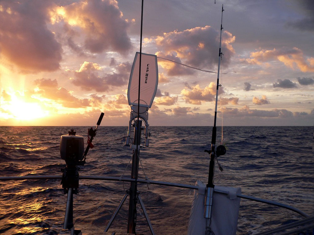
Cappy, our wind vane, happily steering Moana for the 3,000 mile passage
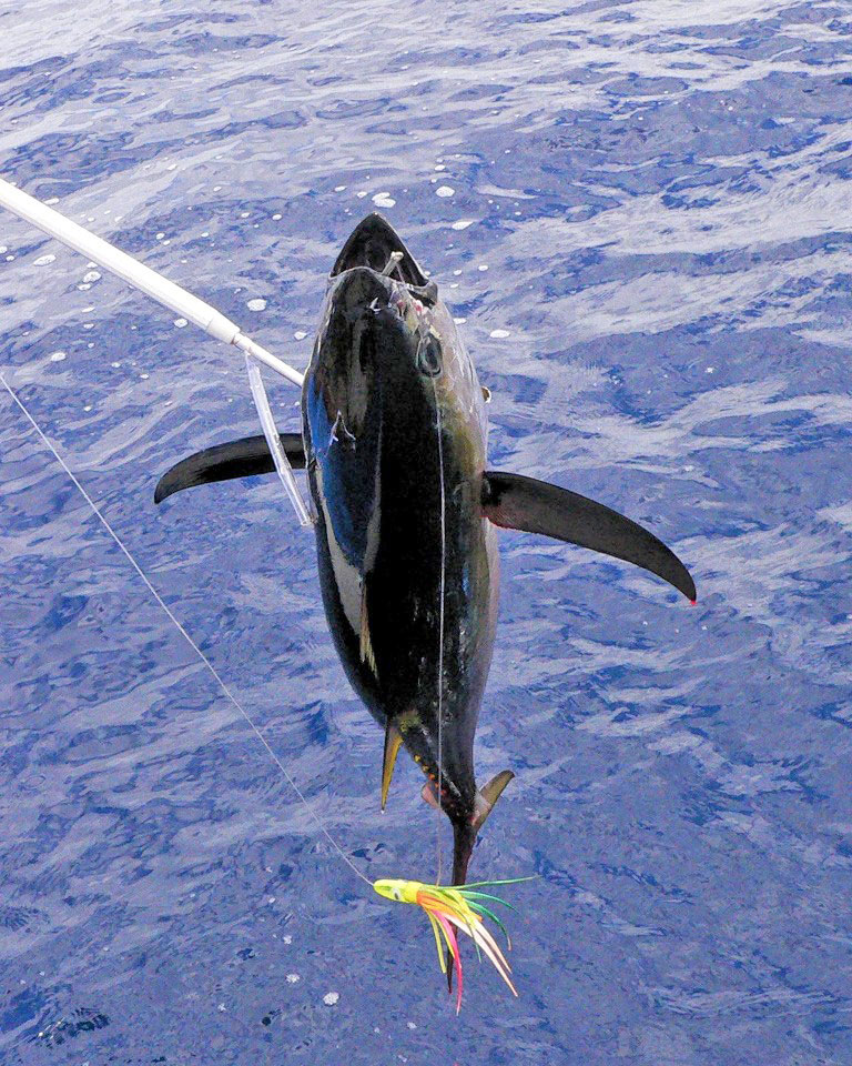
A bigeye tuna caught on Sally's birthday
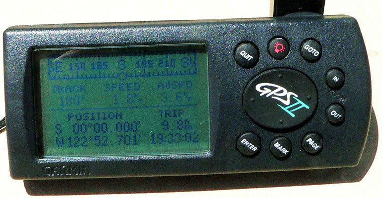
The GPS registering all zero latitude on the equator